Land access easement: how to check legal access
A well-worn road, a gate used for years or a promise that the neighbour allows access are not enough when buying land or a house. Access must be checked in the documents, cadastral records and on the ground, before the advance payment.
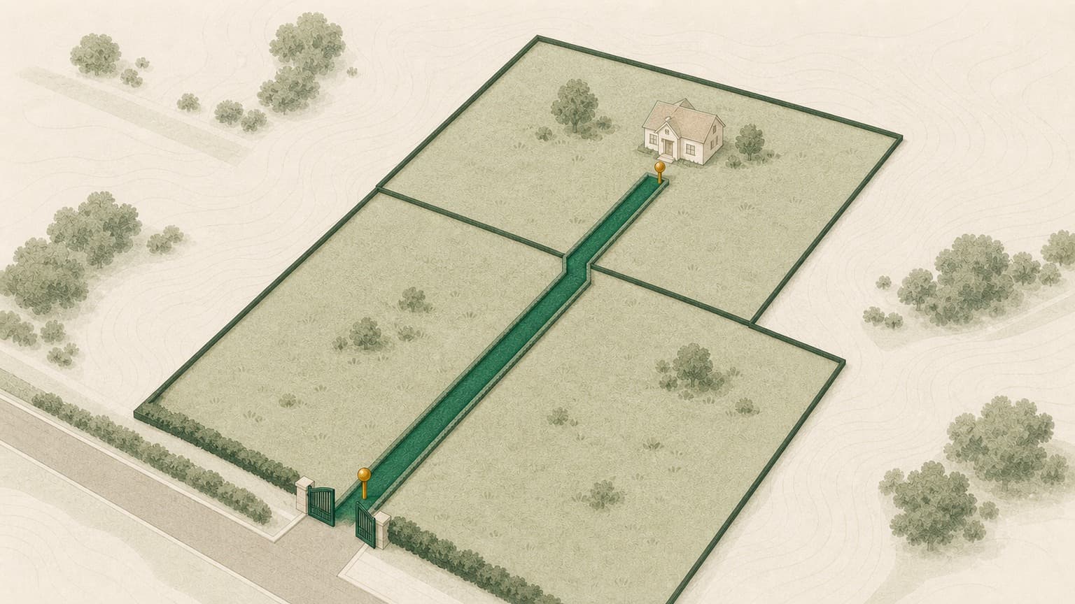
Visible access on the ground does not automatically mean legal access. Check whether the road is public or the right of way is registered and documented.
In the land register, the easement must be understood from both perspectives: the property benefiting from it and the property crossed.
The cadastral plan and orthophoto help you see whether the route used in practice corresponds to the officially registered boundaries.
For land and houses on private roads, Verifi Complet is usually more suitable than Standard, because it adds context about the seller, litigation and risk.
How to check the access road
A road used in practice is not enough. You need to see the registered right or the documents supporting it.
Verifi helps you prepare the right questions and identify important warning signs. For complex legal situations, clarify the decision to sign with your notary or lawyer.
The road must be legally secure, not merely visible
The aerial image shows the road, but the right of way is confirmed in the documents.
Informal access may work for years, until the neighbouring owner changes.
Why legal access can change a property's value
For land and houses, access is not an administrative detail. It can determine whether you can drive in, obtain a building permit, have the property accepted as security by a bank and resell it easily. A plot with uncertain access may look cheap, but the discount quickly disappears when court cases, negotiations with neighbours or road and utility costs arise.
The problem often occurs in areas with successive subdivisions, new neighbourhoods, former agricultural land or old houses where people have used an informal route for years. The situation on the ground may be convincing, but the buyer needs something more solid: a registered right, clear route, usable width and documents that stand up to scrutiny by the notary, bank and permitting authority.
Public or private road: the first important distinction
The first question is simple: is the road providing access to the property public or private? If it is public, check whether the plot directly fronts it and whether this frontage appears on the cadastral plan. If it is private, find out who owns it, who maintains it and what right you have to use it.
A private road may be a separate plot owned in shares by all owners in the development, by the developer, a neighbour or a company. Each arrangement has consequences. If the road remains with the developer, ask what safeguards you have against them imposing conditions on access, selling the plot or refusing utility works. If it is owned in shares by the property owners, check that you will receive the relevant share in the sale.
Also be careful with roads promised to the local authority. Transfer into public ownership is a process, not simply an intention. Request documents: decisions, subdivision deeds, handover records or written confirmation from the authority, as applicable.
The right-of-way easement: what it is and how to read it in practice
In simple terms, a right-of-way easement is a right in rem allowing one property to use part of another for access. Under the Civil Code, a right of way applies where a property lacks access to a public road: the owner may request passage over the neighbour's land, under conditions that cause minimum inconvenience to the owner of the property with public road access. Article 617 of the Civil Code is the basic legal reference, and Verifi helps you see whether the documents and plan support the claimed access.
For the buyer, the question is not just whether an easement exists, but how it is described:
- Who benefits: the property you are buying must be the dominant property or have its right of access clearly stated in the documents.
- Who bears it: the neighbouring property crossed is the servient property. The easement should also appear in that property's relevant land register.
- The route: the road's width, length and location must be identifiable, ideally through an attached plan.
- How it may be used: pedestrian access, vehicle access, machinery, works, maintenance and utilities do not always mean the same thing.
The law on cadastre and land registration treats the land register as a system for publicising rights in rem and other legal relationships subject to publicity. For easements, what matters is that the right is enforceable against third parties and verifiable, not merely described verbally. Verifi brings the land register extract, plan and orthophoto into the same check, so you can see sooner whether access is merely used or also documented.
Verifi brings together the land register extract, orthophoto plan and risk indicators worth discussing with the notary or cadastral surveyor in one report.
Land register, cadastral plan and orthophoto: how to compare the documents with the land
A thorough check does not stop at the land register extract. You need to place three views of the same reality side by side: what the land register says, what the cadastral plan shows and what is visible in the orthophoto or on site.
1. The land register extract
The encumbrances section may show easements, rights of way, prohibitions or other rights in rem. Check whether the description is sufficiently specific. A vague entry without a route or a link to the plan needs clarification.
2. The cadastral plan
The plan must show the plot's boundaries and, where applicable, the road or area affected by the easement. If the access in use crosses another plot, ask who owns that land and what right exists to use it.
3. Orthophoto and site visit
The orthophoto helps you observe routes actually in use, gates, fences, dirt roads, buildings erected near the road or differences between the map and reality. It is not conclusive legal evidence, but is excellent for identifying questions you would otherwise not ask.
Utilities across neighbouring land: access is not just for cars
Buyers usually check whether they can enter the land. It is just as important to know where water, sewerage, gas, electricity or fibre will enter. If networks must cross the neighbour's land, a vehicular right of way does not automatically cover the right to install, repair or replace pipes and cables.
The Civil Code also separately regulates passage for utilities and the execution of certain works, and the precise wording of the right matters. For new utilities, exceptions and conditions can be sensitive, especially where the route would affect yards, gardens or buildings. It is therefore advisable to request written technical solutions from utility operators, not just verbal estimates.
- Ask whether location approvals or technical solutions exist.
- Check whether the easement mentions utilities, not just access.
- Find out who pays for installation, repairs and restoring the land to its original condition.
- Ask the cadastral surveyor to confirm whether the route can be clearly mapped and registered.
Shared private roads: shares, maintenance and disputes between neighbours
In many new neighbourhoods, access is via a shared private lane. This can be perfectly acceptable if the documents are in order. Risk arises when the road is a separate plot without clear rules on ownership, maintenance and use.
In particular, check:
- Road share: are you also buying a share in the road plot, or only receiving an easement?
- Actual width: can two cars pass, or a fire engine, concrete mixer or refuse collection vehicle get through?
- Maintenance rules: who pays for gravel, asphalt, snow clearance, lighting, drainage channels and repairs?
- Third-party access: are there barriers, gates, access controls or restrictions that may create disputes?
- Future subdivisions: the road may become inadequate if more plots behind it are sold.
If the private road is essential to the property, request a land register extract for the road plot as well, not just for the land or house you are buying.
What to ask the seller, notary and cadastral engineer
When access is unclear, good questions save time and money. Ask them before reservation or the preliminary contract, ideally in writing.
The seller
- What are the cadastral numbers of the land and road?
- Is the road public, private, jointly owned in shares or used under an easement?
- Are there deeds establishing the easement and an attached plan?
- Have there been disputes with neighbours over access or utilities?
- Is the road share also being sold, if the road is a separate plot?
The notary
- Does the land register show sufficient legal access for the transaction?
- Does the servient property's land register also need to be checked?
- Can the preliminary contract make the advance payment conditional on clarifying access?
- Are there risks if the easement is only promised, not registered?
The cadastral engineer
- Does the route used on the ground match the cadastral plan?
- Does the easement have a usable width and geometry for the buyer's purpose?
- Can the route be registered or corrected in the land register?
- Are there overlaps, moved fences or unclear boundaries?
Red flags and how Verifi helps
Some indicators do not automatically prevent the transaction, but mean you should not pay an advance without clarification:
Verifi Standard (179 RON) is useful for an initial check: official ANCPI land register extract, encumbrance analysis and cadastral/orthophoto context. It is suitable where the property appears to have direct access to a public road and you need to screen basic risks quickly.
Verifi Complet (299 RON) is recommended for land, houses on private roads, rear plots, subdivisions and situations involving a company seller. It adds further seller checks, litigation and risk context, precisely the areas where access problems tend to connect with other risks.
Verifi does not make a legal decision on whether you can buy. It shows what appears in the available sources and what needs to be taken further with a notary, lawyer or cadastral surveyor, in clear, actionable language.
Frequently asked questions
Does a road used on the ground mean legal access?
Not automatically. A well-worn road, a gate used for years or a promise that the neighbour allows access are not enough. Access must be checked in the documents: the road must be public or the right of way registered and documented, with a clear route.
What is a right-of-way easement?
A right in rem allowing one property to use part of another property for access. Under the Civil Code, the right of way applies where a property lacks access to a public road, and Article 617 is the basic legal reference. The benefiting property is the dominant property, while the neighbouring property crossed is the servient property.
Does a vehicular right of way also cover utilities?
Not automatically. If networks must cross the neighbour's land, a vehicular right of way does not automatically cover the right to install, repair or replace pipes and cables. Check whether the easement mentions utilities, not just access, and request written technical solutions from operators.
What should I check for a shared private road?
Whether the sale includes a share in the road plot or only an easement, the road's actual width, maintenance rules (who pays for gravel, asphalt, snow clearance, lighting and repairs), and any barriers, gates or access restrictions. If the private road is essential to the property, request a land register extract for the road plot as well.
What should I do if access exists on the ground but does not appear in the land register?
This does not automatically mean the transaction is impossible, but it means the situation must be clarified before the advance payment, with the notary and cadastral engineer.
Find the property on the map and check access in context.
For land, houses on private roads or subdivided plots, Verifi Complet is the natural choice: it includes land register and orthophoto analysis plus additional seller, litigation and risk checks.
Check on the map